Extremwetter mit starken Gewittern in Süddeutschland im Juni 2021

Peter Engelmann,  3 Juli, 2021

2021: Mit einem kalten Frühling blieben die Temperaturen im Mai unter dem Durchschnitt. Zum Glück gab es in vielen Teilen von Deutschland endlich viel Regen nach einer seit 2018 anhaltenden Dürre. Diese hatte in einigen Regionen zu Waldschäden und führte bereits zu Sorgen über die Zukunft des Wasserhaushaltes und der Trinkwasserversorgung. Im Juni folgte eine Hitzewelle. Im Unterschied zu früheren Jahren kam es aber nicht zum Aufbau langanhaltender stationärer Hochdrucksysteme über Europa. Die Wettersituation war nicht über lange Zeit stabil. Die Hitzewelle wurde durch extreme Wetterereignisse beendet. Wieder einmal gab es Situationen, zum Beispiel in Südwestdeutschland (Reutlingen) oder einer Überflutung in Landshut, wie es sie so in der Erinnerung der Menschen noch nie gegeben hat. Darauf folgten viele Diskussionen, ob dies eine Folge des Klimawandels sei oder einfach einzigartige Wetteranomalien.

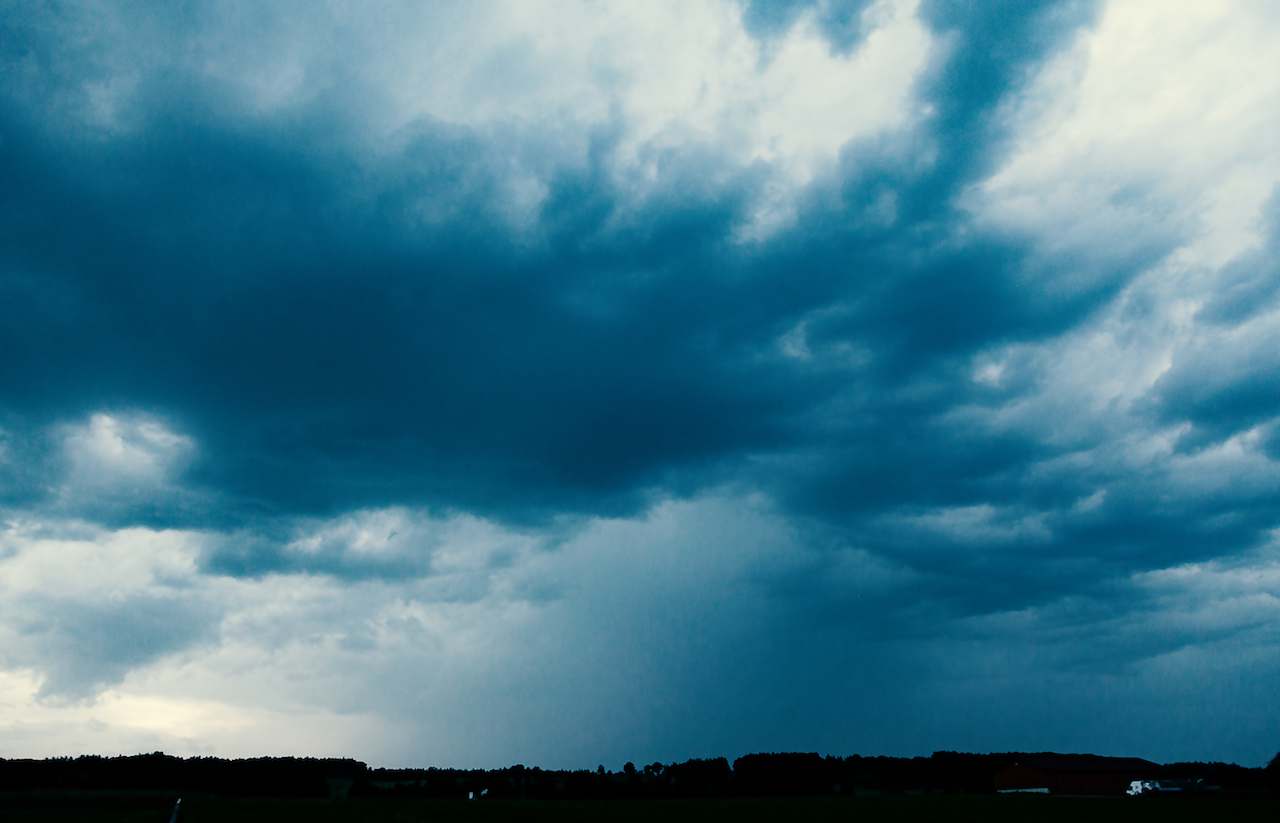
Nach der Hitze änderte sich in Bayern das Wetter am 20. Juni 2021. Die Tage davor war es überwiegend trocken gewesen mit Ausnahme erster Gewitter im Südwesten Deutschlands und ind den Alpen. Am 20. Juni begann es am Standort am westlichen Ammersee zu grummeln und ein Gewitter mit nur sehr wenigen Blitzen war dort zu sehen. Wie immer gab und gibt es große regionale Unterschiede auf kleinem Raum: Bald gab es starke Gewitterstürme, aber manchmal passierte ein paar Kilometer weiter gar nichts. Das ist nicht ungewöhnlich und bis heute eine Herausforderung für die Wettervorhersage.

Gewitter in den frühen Abendstunden des 20. Junis bei St. Georgen, Diessen, Ammmersee:

Kurzlebige Gewitterzelle am 20. Juni 2021

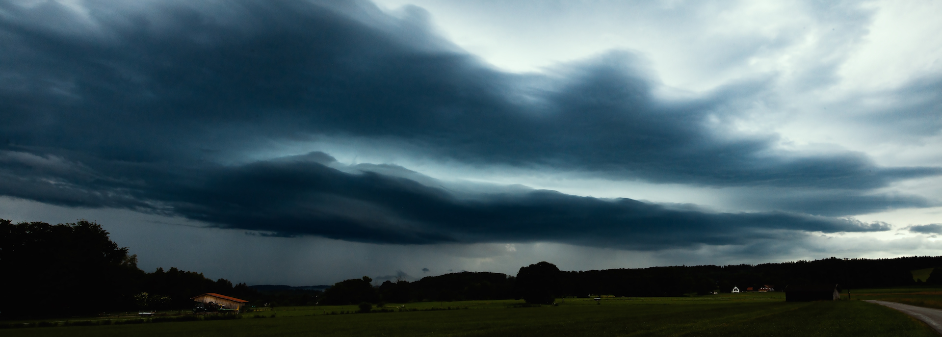
Die nächsten Tage gab es eine andere Wettersituation: In den späten Nachmittagsstunden oder am Abend kam es zu sehr starken Gewittern. In Süddeutschland wurden auch rotierende Superzellen beobachtet. Noch viel extremere Gewitter gab es in Frankreich, wo eine Luftmassengrenze tagelang für regelrecht katastrophale Zustände sorgte. Die großen Gewittercluster formten sich in Frankreich immer wieder und zogen nach Belgien und Nordwestdeutschland.

Starkes Gewitter am 24. Juni, ca. 18.45 bei Diessen (Ammersee, Oberbayern)

Sich näherndes Gewitter am 24 Juni 2021

Das extreme Wetter mit schweren Gewittern, Sturzfluten, extremen Hagel dauerte in Deutschland mehrere Tage an. Der Grund: Die Luftmassengrenze in Europa verlagerte sich nur sehr langsam. Sie funktionierte wie eine Maschine und erzeugte immer wieder neue Gewitter. Ein Zeitraffervideo vom 21. Juni 2021 gibt eine Idee davon, wie schnell sich oft die Gewitter entwickelten:

Es war interessant zu beobachten, dass ganz unterschiedliche “Typen” von Gewittern auftraten. Am Beobachtungstandort im Südwesten der Ammerseeregion gab es sehr kurzlebige Gewitter, ein Gewitter, das unglaublich schnell aufzog und dann wieder ein Gewitter, das sich nur sehr langsam bewegte. Bei so einem Gewitter konnte man sehr gut Bilder machen. In der Nacht gab es auch etwas, was von manchen als “Stroboskopgewitter” bezeichnet wird. Gewitter, bei denen man gar nicht so viel lauten Donner hört, aber wo es eine unglaublich hohe Rate an Blitzen gibt. Bei den Gewittern gab es auch welche mit sehr starkem Wind aber auch welche, wo kaum ein Wind wehte.

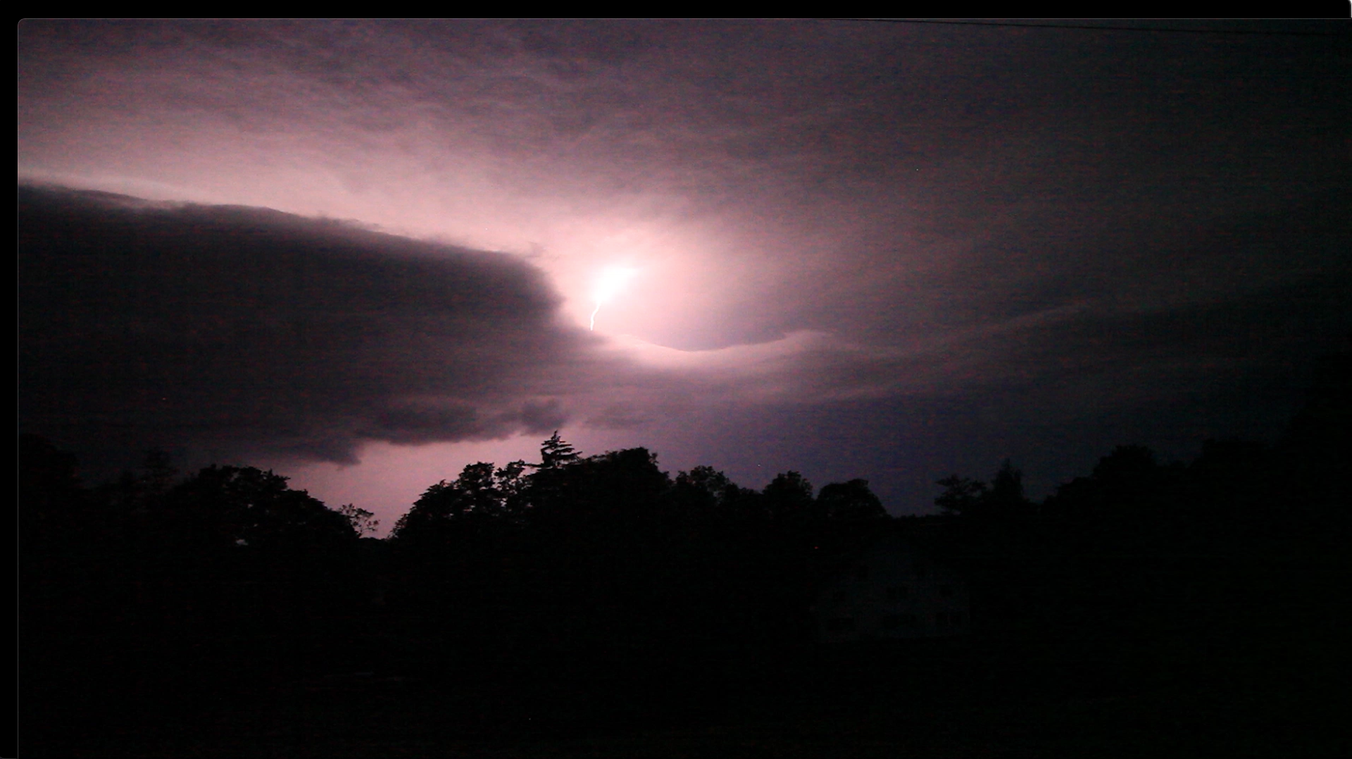
Das Gewitter am 24 Juni erzeugte einige großartige Blitze:

Gewitter am 24. June 2021

Der Gewittersturm unten zog am 28 Juni 2021 auf und war von intensivem Blitzgeschehen begleitet, jedoch völlig anders als das oben erwähnte “Stroboskopgewitter” in der Nacht davor. Die Blitze waren hier viel besser sichtbar. Nach einem der Gewitter gab es auch einen dicken Nebel nach Sonnenuntergang. Später gab es aber am gleichen Abend noch ein Gewitter mit vielen Blitzen. Die stärksten Gewitter kamen dabei meisten aus der Richtung der Alpen.

Gewitter am späteren Abend, 28. Juni 2021, ca. 22.00 Uhr:

Blitze am 28. Juni 2021

Sturzfluten und Superzellen

Schließlich kam es zu einem Austausch der Luftmassen. Die warme, feuchte Luft wurde durch kältere Luft ersetzt. Der 29 Juni war der vorläufige Höhepunkt dieser Gewitterserie in in Deutschland: In Bayern intensivierte sich ein Superzellengewitter, das aus Baden-Württemberg kam und brachte in Landshut in Niederbayern unglaubliche Regenmengen, die die Stadt regelrecht unter Wasser setzten. Die Tage davor kam es zu einem Tornado in der in Tschechien( Czech republic). Das Video unten zeigt die Situation nach dem großen Gewitter am 29. Juni, bei dem es in Oberbayern auch starken Wind gab.

Hier ist ein Punkt, der auch für Photographen und Filter interessant sein kann: Die meisten Leute sind daran interessiert, ein Gewitter aufzunehmen, wenn es heranzieht. Aber es gibt auch noch viele interessante Stimmungen und Momente, wenn das Gewitter durchgezogen ist. Das Video unten zeigt die Atmosphäre nach dem Gewitter am 29. Juni.

Extreme Weather In Southern Germany June 2021

Peter Engelmann, July 3, 2021

2021: A cold spring with temperatures in May below average. Luckily there was lot of rain in parts of Germany after a drought since 2018 in some areas which damaged trees and raised serious concerns for example about the future of the water balance and water supply. In June a heat wave followed. However unlike in previous years there were no long lasting high pressure systems. The weather situation wasn’t so far stable for a long time. The heat wave ended with some extreme weather events. And again, we had situations for example in South-West-Germany or in Landshut, lower Bavaria, which were unprecedented. There are a lot of discussions now going on if this is climate-change related or if it is another rare weather pattern.

Things began to change in Bavaria June 20, 2021. The days before had been mostly dry except first thunderstorms in the Southwest and in the Alps. On June 20 there were some rumble and not so intense lightning in the region west of lake Ammersee. As usual there are huge local differences: There were soon stronger thunderstorm whereas a few kilometres apart from that place nothing or little happened. That’s very usual and always challenges weather forecasters.

Thunderstorm in the early evening hours of June 20:

Short lived thunderstorm cell June 20, 2021

The next days there was a much different weather situation: In the late afternoon or evening real strong thunderstorms occurred. Rotating supercell storms were also reported in the Southern Germany. Even more extreme weather happened in France where an air mass boundary created havoc. In France huge clusters of thunderstorms formed repeatedly and moved to Belgium and North-West Germany.

Strong thunderstorm on June 24, 6.45 p.m. near Diessen (Lake Ammersee, Upper Bavaria)

Thunderstorm approaching June 24, 2021

The extreme weather with strong thunderstorms, flash-floods, even extreme hail with enormous hailstones and masses of hail lasted for a couple of days. The reason: The air mass boundary moved only slowly in Europe. It worked like a machine charging up the atmosphere and creating new thunderstorms. A time-lapse video from June 21, 2021 late afternoon gives you some idea how quickly the storms formed:

It was interesting that there were very different types of thunderstorms. The location southwest of the Ammersee experience short-lived thunderstorms, a thunderstorm which arrived very quickly as the next day there was slow movement and plenty of time to take pictures. In the night there was also one of the “stroboscope”-like thunderstorms, where you hear not much loud thunder but you see an incredible light show with high rates of flashes. There were both thunderstorms without wind and thunderstorms with very strong wind.

The thunderstorm on June 24 created some great lightning:

Lightning June 24, 2021

The storm below occurred June 28, 2021 and brought intense lightning. However it was completely different as the “strobe-storm” the night before before. The lightning was also better visible. After one of the storms there was also a thick mist around sunset. Later the mist vanished and another thunderstorm with strong lightning occurred. The stronger storms came mostly from the Alps.

Thunderstorm in the evening of June 28, 10.00 p.m:

Lightning June 28. 2021

Flash Floods and Super Cell Storms

Finally there was an exchange of air mass. The hot humid air was replaced by colder air. June 29 was the climax of the series of thunderstorms in Germany: In Bavaria, a super-cell coming from Baden-Württemberg, intensified and brought an incredibly flash flood in Landshut Lower Bavaria. The days before a deadly tornado happened in the Czech republic. The video shows the aftermath of the big storm on June 29 which was accompanied by very strong winds.

Here is also an interesting thing for photographers and videographers: Usually most people are interested to catch a storm coming to them or before it happens. But there is a lot of possibilities to get interesting moods and pictures when the storm passed. The video belows shows what was going on in the atmosphere after this huge thunderstorm on June 29.

Berlin, July 22, 2017: The Flood Again

Again scenes looking like from Roland Emmerich’s “Day After Tomorrow”. Roughly three weeks after the flooding with lots of damage the German capital was again hit by severe weather. A thunderstorm and torrential rain hit the city on Saturday afternoon when many people were celebrating the Christopher-Street-Day-Parade. Luckily it didn’t affect much of the parade, but also this time there was a state of exception.

In some parts of the city particularly in the North and North-East but also in the South-West a lot of rain came down, and in Pankow, a storm left a trace of destruction. Trees fell on cars, the S-Bahn Linie 2 commuter train was interrupted in the North for some time, also the tracks of a street-car were affected.

Also again there was a lot of water on some streets turning them into canals like three weeks before. It’s noteworthy that often car drivers are obviously not conscious about the danger for their cars and perhaps also for themselves: if you drive into a puddle of water and the level of water is high enough its possible the water is sucked into the air filter. Subsequently, the engine could be completely destroyed. Cars could also become deadly traps if the car is drowning in a flooded underpass and the doors cannot any longer be opened.

If possible try to avoid driving when these type of flash-floods occur which are a novelty in Germany with this kind of intense rain and also the fact that we have now repeated events of that kind in shorter time-periods during summer.
<


It certainly looks like one of the predicted effects of climate change; for a long time, scientists warned of higher levels of moist air in the atmosphere during summertime. These wet air masses can lead to more extreme weather like heavy thunderstorms and extreme rain.

Obviously, it’s not yet possible to have a more precise forecast or nowcast about thunderstorms with extreme flooding. Forecasts were very precise this day about the time when the bad weather was supposed to arrive around 3-4pm in the afternoon, and there was also a warning about heavy rain, but it’s, of course, impossible to say where exactly the most extreme events do happen.

For example, the south-west of Berlin is usually less affected by severe thunderstorms as the North but there are exceptions from the rule. This time an underpass in Zehlendorf (South-West) got flooded. During the last event, the biggest mass of rain hit quarters in the west (Wilmersdorf) and a city north of Berlin, Oranienburg, where thunderstorms are more often.

Luckily the rain didn’t last as long as two weeks ago. Therefore it was another extreme day for police and fire-starters but it should be less damage as during the previous extreme weather event.


June 29, 2017: State Of Exception In Berlin Due To Epic Rainfall

Berlin and North-East-Germany have an increasing problem due to climate change: it’s getting too dry. Statistically, the annual precipitation amount in Berlin is around 550mm or less. The City and Brandenburg, which is the driest province in Germany, are situated between the continental climate regions in Eastern Europe and the West of Germany which is influenced by a more maritime climate. Often rainfall from low-pressure systems coming in from the west side doesn’t reach Berlin. But with every new year, there was even less rain.

In June 2017 there was news about problems with sinking phreatic levels and lakes in the Barnim ( a region in the North-East of Berlin) even dried out. This was shortly before a big surprise which kept fire-starters and police awake for more than 24 hours.

June 29 will be a day remembered for a historically unseen weather event. The day before brought already some severe weather with thunderstorms but at sunset, things looked calm. After some rain meadows and fields were covered with a thin layer of mist.

Only the typical cirrus clouds and weather reports indicated rain coming in for the next day.

There was indeed a flood warning in place but what happened then exceeded all expectations. In 24 hours there were 196,9 mm liters of rain per square meter in Tegel, which is the quarter of the city with the airport in the North-West. But all other parts of the city were hit by the epic flashflood too. It was like Noah’s Flood since the torrential rain didn’t stop for many hours.


Luckily there were so far no casualties but dramatic damage in various places: The U9 subway in the west was affected when parts of a tunnel were flooded, airplanes couldn’t land, many streets were underwater and a building had to be evacuated because of fears it could collapse. An endless number of cellars got flooded. Berlin’s fire-starters did an incredible job. There were over 2000 emergency responses. It was not before afternoon the next day that the state of emergency was canceled.

However, it is an eery silence at the moment. For some hours it was dry but in the late afternoon, there were again some torrential rain showers. The situation is still dangerous because trees could fall and levels of rivers are rising. There is more rain predicted for the next days.

The reason for this epic flood was an unusual weather-pattern with two low-pressure systems and extreme wet air in the Berlin-Brandenburg region. The wind was blowing from different directions. The clouds were circling around and some of them even moving back again due to the conditions in the atmosphere.

Not any extreme weather event is related to climate change but this type of tropic torrential rain is very unusual and fits in certain patterns which were predicted by scientists a long time ago. On the other side there was a flood in Berlin on April 14, 1902, which left strong memories long before global warming was an issue.

In any case, its time to take some precautions. Berlin will build new and huge water storages for the future. Today we are in praise for our firefighters who helped so many.